


Featured Image: ULA
Lift Off Time | September 27, 2021 – 18:12 UTC | 11:12 PDT |
|---|---|
Mission Name | Landsat 9 |
Launch Provider | United Launch Alliance (ULA) |
Customer | National Aeronautics and Space Administration (NASA) and United States Geological Survey (USGS) |
Rocket | Atlas V 401 |
Launch Location | SLC-3E, Vandenberg SFB, California, USA |
Payload mass | N/A |
Where did the satellites go? | Sun synchronous orbit |
Did they attempt to recover the first stage? | No, this it not a capability of ULA |
Where did the first stage land? | It crashed into the Pacific Ocean |
Did they attempt to recover the fairings? | No, this is not a capability of ULA |
Were these fairings new? | Yes |
How was the weather? | Heavy and thick fog |
This was the: | – 39th launch of an Atlas V launch vehicle in the 401 configuration – 83rd launch of an Atlas V launch vehicle – 16th launch of an Atlas V rocket from Vandenberg – 300th launch of an Atlas rocket from Vandenberg – 145th mission for United Launch Alliance – 1st 4 burn flight for a Centaur Upper Stage – 94th orbital launch attempt (88th successful) |
Where to watch | Official replay |
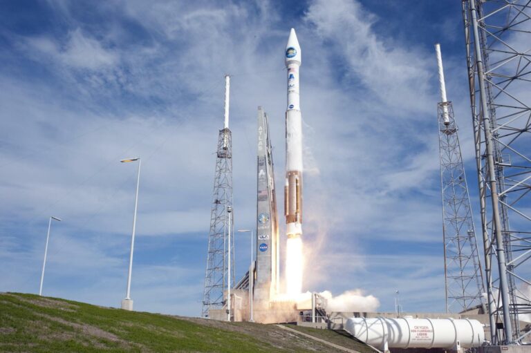
How did it go?
United Launch Alliance has successfully launched the Landsat 9 satellite into its desired orbit. Atlas V lifted off at 11:12:00.153 am PDT from a very foggy Vandenberg Space Force Base after a nominal countdown. The Centaur Upper Stage had experienced a sticky LOX valve, but after some cycling, the issue was resolved without the need for on hands intervention. The timeline after liftoff proceeded smoothly and all payloads were deployed.

What’s on Landsat 9?
Landsat 9 has instruments that will all perform critical roles in the data collection. Landsat 8 hosted similar instruments, but its successor will be equipped with upgraded versions. These instruments include, but are not limited to the Operational Land Imager 2 (OLI-2) and Thermal Infrared Sensor 2 (TIRS-2). Each of these instruments will image many aspects of Earth through different bands of light. When combining the capabilities of both instruments, the number of bands total eleven. The spacecraft bus, which is the main body/powerhouse of a satellite, was developed by Northrop Grumman Aviation Systems (formerly Orbital ATK).
The Landsat program can be traced back to the Earth Resources Technology Satellite, launched on 23 July 1972. This satellite flew on a Delta 900 rocket, which launched from Vandenberg Air Force Base (as it then was) in California. It was “the first Earth-observing satellite to be launched with the express intent to study and monitor our planet’s landmasses”, according to NASA. The Earth Resources Technology Satellite was then renamed to Landsat 1 once on orbit.
Since that date, one or more Landsat satellites have provided continuous Earth monitoring for nearly 50 years. During the lifetime of the program, only Landsat 6 failed to reach orbit. This occurred after it encountered an explosion in its liquid fuel system at the time of separation of the payload from its Titan II launch vehicle.

Data processing will be conducted by the USGS and will be inventoried in the Worldwide Reference System-2 (WRS-2). Landsat 9 will conduct as many as 750 scenes or groups of images each day and will combine with Landsat 8 to bring that total to 1,500. The data products can be downloaded by anyone interested from the USGS Earth Resources Observation and Science (EROS) Center.
Operational Land Imager 2 (OLI-2)
Operational Land Imager 2 (OLI-2) will have the capability of imaging the surface of the Earth in the visible, near infrared, and shortwave infrared sections of the electromagnetic (EM) spectrum. The human eye can only see the very narrow visible part of the spectrum, but instruments like these enable humans to see much greater spectrum and different details. When separated into their specific bands, OLI-2 will be able to image in nine different bands. A band is a range of pre-specified wavelengths.
| Band Number | Part of EM Spectrum | Wavelength Range | GSD* (meters) |
| 1 | Ultra Blue | 0.43 – 0.45 µm | 30 |
| 2 | Blue | 0.450 – 0.51 µm | 30 |
| 3 | Green | 0.53 – 0.59 µm | 30 |
| 4 | Red | 0.64 – 0.67 µm | 30 |
| 5 | Near-Infrared | 0.85 – 0.88 µm | 30 |
| 6 | Short Wave Infrared | 1.57 – 1.65 µm | 30 |
| 7 | Short Wave Infrared | 2.11 – 2.29 µm | 30 |
| 8 | Panchromatic | 0.50 – 0.68 µm | 15 |
| 9 | Cirrus | 1.36 – 1.38 µm | 30 |
By combining each band, the USGS, who will interpret large majority of the data, will be able to create full color images (from bands two, three, and four) as well as view Earth from the infrared wavelengths to acquire details not otherwise seen.
Thermal Infrared Sensor 2 (TIRS-2)
Similarly to OLI-2, TIRS-2 is also just an upgraded version from the older instrument on the Landsat-8 satellite that images in multiple bands. TIRS-2 will be in charge of imaging the thermals or heat coming from parts of the Earth via the infrared bands.
| Band Number | Part of EM Spectrum | Wavelength Range | GSD (meters) |
| 10 | Thermal infrared | 10.60–11.19 µm | 100* |
| 11 | Thermal infrared | 11.50–12.51 µm | 100* |
Other Payloads
In addition to Landsat 9, there were a few smaller CubeSat payloads hitching a ride. Two 6U CubSats developed and built by universities will be flying as a part of Educational Launch of Nanosatellites 34 (ELaNa 34). CUTE (Colorado Ultraviolet Transit Experiment) was developed but the University of Colorado Boulder and is aiming to study exoplanets via the ultraviolet spectrum. Also flying with ELaNa 34 is CuPID (Cusp Plasma Imaging Detector), which was developed by Boston University and will measure the interaction between the solar wind and the upper reaches of Earth’s atmosphere.
What is the Atlas V?
The Atlas V is an expendable medium lift launch system and member of the Atlas rocket family. The rocket is one of the most reliable in the world, having now flown 77 launches with no complete failures.
The rocket has two stages. The first is a Common Core Booster (CCB), which is powered by an RD-180 engine and burns kerosene (RP-1) and liquid oxygen (LOx). This is accompanied by up to five strap-on solid rocket boosters. The second stage is the Centaur upper stage, which is powered by one or two RL10 engines and burns liquid hydrogen (LH2) and liquid oxygen (LOx).
What does 401 mean?
Atlas V rockets have a three number configuration code. The first number represents the fairing diameter size in meters, so in this instance there is a 4 meter fairing. The second number denotes the number of solid rocket boosters (SRBs), which attach to the base of the rocket. The number of SRBs for a 4 meter fairing can range from 0 – 3. In this case there will be 0 SRBs attached to the center core. The third number shows the number of engines on the Centaur Upper Stage, which is 1 in this configuration. For this launch, the Atlas V rocket will have a 4 meter faring, 0 solid rocket boosters, and 1 engine on the Centaur Upper Stage.
