


Featured image credit: ISRO
Liftoff Time | February 17, 2024 – 12:05 UTC | 17:35 IST |
|---|---|
Mission Name | INSAT-3DS |
Launch Provider | The Indian Space Research Organization (ISRO) |
Customer | India’s Ministry of Earth Sciences (MoES) |
Rocket | GSLV Mk II F14 (Geosynchronous Satellite Launch Vehicle Mark II) |
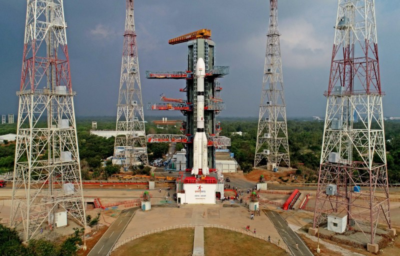
Launch Location | Second Launch Pad (SLP), Satish Dhawan Space Centre, Sriharikota, Andhra Pradesh, India |
Payload mass | 2,274 kg (~5,010 lb) at launch, dry mass 907 kg |
Where did the satellite go? | To a geosynchronous equatorial orbit (GEO), meaning at 35,786 km (~22,240 mi) altitude and 0 degrees inclination; Initially, a geostationary transfer orbit (GTO) of 170×36,647 km (~105×22,780 mi) x 19.35° |
Did they attempt to recover the first stage? | No, the GSLV Mk II rocket does not feature this capability |
Where did the first stage land? | It crashed into the Bay of Bengal |
Did they attempt to recover the fairings? | No, the GSLV Mk II rocket does not feature this capability |
Were these fairings new? | Yes |
This was the: | – 10th launch of a GSLV Mk II – 7th flight of the INSAT-3 series – 16th launch of a GSLV (Mk I or II – GSLV Mk III is a different rocket entirely) – 36th launch from Second Launch Pad – 95th launch from Satish Dhawan Space Centre – 33rd orbital launch attempt in 2024 |
Where to re-watch | ISRO’s official replay on Youtube |
What’s All This Mean?
ISRO launches a GSLV Mk II rocket carrying the weather satellite, INSAT-3DS, for India’s Ministry of Earth Sciences. Liftoff takes place from the Second Launch Pad, at Satish Dhawan Space Centre, in the Sriharikota Island. Once the payload separates from the launch vehicle, it will follow a trajectory leading it to a geostationary orbit. By its own means, the satellite will later reach a certain spot in said orbit, where it will reside and operate.

How Did It Go?
ISRO’s launch vehicle, the GSLV Mk II began its flight normally once the countdown reached its end. The engines roared to life so the rocket could leave the pad following an almost due east heading. Subsequently, one-by-one all launch milestones were nominally achieved, including first stage and strap-on boosters separation, faring jettisoning, and second stage separation. Finally, the INSAT-3DS satellite was correctly deployed into the targeted orbit, giving a successful closure to this launch mission.
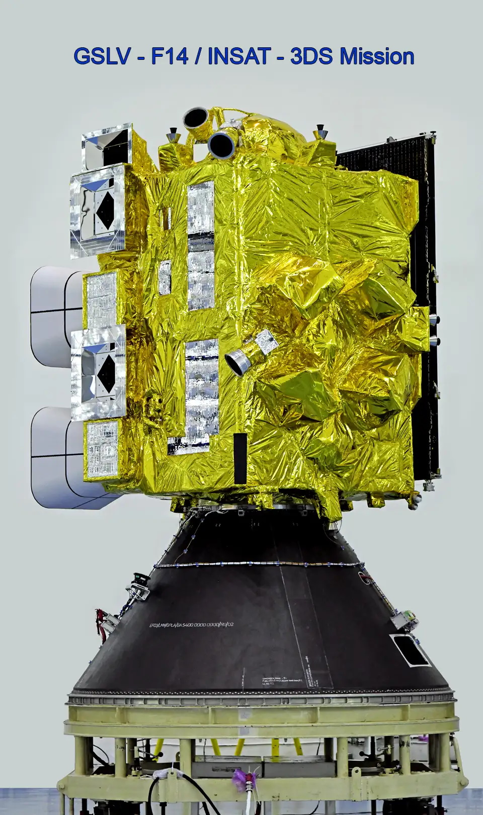
What Is INSAT-3DS?
The Indian National Satellite – 3D, Second Repeat, shortened as INSAT-3DS, is an Indian weather satellite. Previously, six spacecraft belonging to the INSAT-3 family launched to GEO, where only two remain operational: INSAT-3D, and INSAT-3DR. ISRO built the follow-up “3DS” satellite for its customer: the Indian Ministry of Earth Sciences (MoES), while INSAT’s Coordination Committee will operate it. Throughout its expected 10-year lifetime, the unit will reside at the 74 degrees east spot, on the previously mentioned orbit.
For its platform, ISRO used the I-2K bus, enabling a total mass of 2,000 kg (~4,400 lb), or more. Accordingly, the INSAT-3DS will feature a mass of 2,274 kg (~5,010 lb) at launch, and a dry mass of 907 kg (~2,000 lb). Furthermore, a two-section solar panel, arranged in an only wing configuration, provides 1,505 W of electrical power. Additionally, lithium-ion batteries provide support during periods where the solar panel is blocked from facing the Sun. Regarding propulsion, the satellite showcases an apogee liquid engine generating 440 N (~100 lbf) of thrust.

INSAT-3DS’ Mission Objectives
The following is a list of goals, as provided by ISRO:
- “To monitor Earth’s surface, carry out oceanic Observations and its environment in various spectral channels of meteorological importance.”
- “To provide the vertical profile of various meteorological parameters of the Atmosphere.”
- “To provide the Data Collection and Data Dissemination capabilities from the Data Collection Platforms (DCPs).”
- “To provide Satellite Aided Search and Rescue services.”
In other words, this satellite will provide meteorological services to India using a 6-channel imager and a 19-channel sounder, as well as search and rescue information, and message relay for terrestrial data collection platforms. Compared to its predecessors, INSAT-3DS presents many improvements to mitigate issues related to black-body calibration, and midnight sun-intrusion.
INSAT-3DS’ Payloads
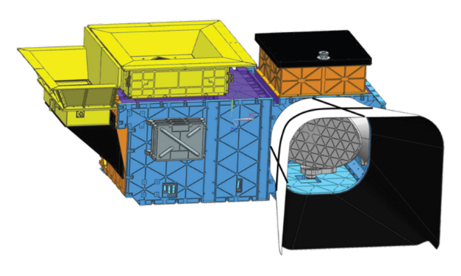
IMAGER (INSAT imager)
INSAT-3DS carries a multi-spectral imager to track water vapor and clouds, obtaining, for example, wind measurements, as a result. Moreover, the instrument should also is capable of characterizing the clouds, indicating how much surface they cover, what type of cloud they are, how high they reach, and their temperature at that altitude. In order to do so, it captures images in the visible and the infrared spectra — six bands in total — by using a telescope and adequate sensors. The telescope needs to physically move to scan the ground, continuously so over the E-W direction, but in steps over N-S.
It presents a mass of 131 kg (~290 lb), while its power consumption reaches 85 W, and its data transmission rate, 3.9 Mbps. In terms of resolution, it depends on the channel, or band, used to take images. That is, it features a resolution of 1.0 km (~0.6 mi) for the visible range of light, but 4.0 km (~2.5 mi) for infrared windows, and 8.0 km (~5.0 mi) for channels observing water vapor. Finally, INSAT-3DS be capable of getting a full disk image every 30 minutes.

SOUNDER (INSAT Sounder)
In order to sound temperature and humidity, this payload will use 19 channels, out of which 18 are in the short-wavelength infrared region, and one is visible. Particularly, the INSAT Sounder will create vertical profiles, meaning it has the capability of detecting temperature, or humidity, values at different altitudes over the same spot on the surface. This is achieved through pointing the instrument at a certain place, keeping it in that orientation for some time, and then moving to the next spot. Keep in mind, though, that the time scale here is smaller than one second.
The sounder is a little heavier than the imager, at 147 kg (~325 lb), but consumes less electrical power, at 76 W. In terms of data rate, it is much slower, at 40 kbps. Every three hours it should cover 6,400×6,400 km2 (~4,000×4,000 mi2). Further, this instrument manages to obtain a 10 km resolution.
DCS (Data Collection Service)
This service uses a transponder of messages coming from in-situ self-timed Data Collection Platforms (DCPs). Relayed data can be of different natures, of different natures, such as meteorological, hydrological and oceanographic. The rates for transmission achieved are of 4,800 bps, transmitting information
SAS&R (Satellite Aided Search & Rescue)
This system takes an emergency signal from a ground-based beacon and redirects it to a control center. Thus, information about where aid is needed ultimately triggers an appropriate rescue operation. Countries like the USA, Canada, France, and Russia, among others, are part of this system named COSPAS/SARSAT.
What Is The GSLV Mk II?
The Geosynchronous Satellite Launch Vehicle (GSLV) rocket, which first flew in 2010, is the Indian Space Research Organization’s (ISRO) heavy lift launcher for placing satellites in high, geostationary orbits around the Earth. The Mk II variant has the capability to carry up to 2,700 kg (6,000 lb) into a geostationary transfer orbit (GTO). This specific variant also features three total stages. Each stage actually uses a different type of fuel. The first stage uses solid fuel, the second stage uses liquid fuel, and the third stage uses cryogenic fuel.

Stage 1 And Strap-Ons
The first stage of the GSLV Mk II vehicle consists of a 139 ton solid rocket motor, which has a nominal burn time of 100 seconds. Contrary to other rockets such as SLS and the Atlas V, GSLV Mk II has a center core which uses solid fuel and four strap-on boosters, which are all powered by liquid propellant. Specifically, the solid fuel used in the center core is Hydroxyl-terminated polybutadiene (HTPB) and can produce 4,700 kN of thrust. As for the liquid strap-ons, they use unsymmetrical dimethylhydrazine (UDMH) and dinitrogen tetroxide (N2O4) and have the capability to produce 680 kN of thrust each for about 160 seconds. Each strap-on booster uses one Vikas engine.
Stage 2
GSLV Mk II features a liquid propellant powered second stage, which uses the same hypergolic propellants and engine as the strap-on boosters. The unsymmetrical dimethylhydrazine (UDMH) and dinitrogen tetroxide (N2O4) propellants feed into a more vacuum optimized Vikas engine, which has the capability to produce 800 kN of thrust for about 150 seconds.
Stage 3
The third and final stage uses cryogenically cooled liquid propellants. These propellants are liquid oxygen (LOx) and liquid hydrogen (LH2). Known as the Cryogenic Upper Stage (CUS), ISRO developed an engine specifically for this stage. It is known as the CE-7.5 and uses a staged combustion system cycle. For more information on the staged combustion system and how different engines work, check out Everyday Astronaut’s video and article on the topic. The CE-7.5 has the capability of producing 75 kN of thrust in a vacuum and can burn for up to 720 seconds.

Rocket section by Austin DeSisto.